Navigator reference
Mission guide, methodology & credits
Selection is not travel
Choose a target to update the dossier and reticle without moving. Visit begins a cancellable route; the breadcrumb and scale ladder continue to describe the current scene until the staged destination takes over.
Keyboard map
- Tab / Shift + Tab
- Move through targets, sources, and controls
- Arrow keys
- Orbit while focus is inside the camera controls
- Shift + Arrow keys
- Move laterally while focus is inside the camera controls
- + / −
- Move closer or farther
- Home
- Travel from any scene to the authored galaxy overview
- Escape
- Stop active travel first; otherwise clear search or close the current overlay
Quality and motion
Auto quality adapts the representative star count to the viewport and sustained frame evidence; High, Balanced, and Reduced lock a tier. Pause stops camera drift and ambient motion while direct camera controls remain available. A reduced-motion preference removes drift, reticle convergence, and spatial HUD glides.
What the galaxy represents
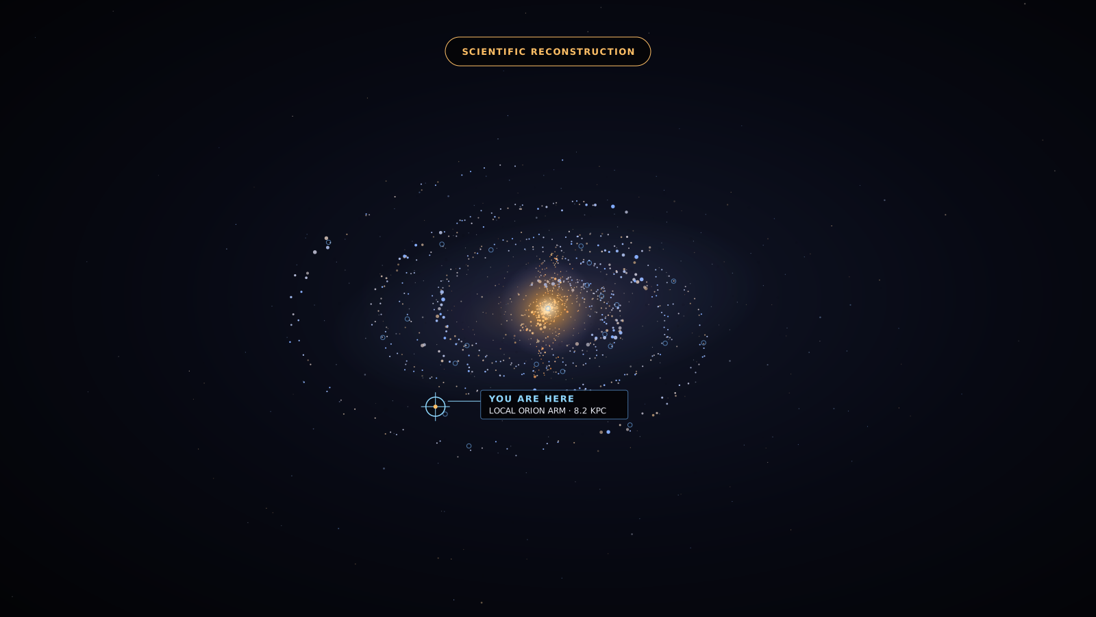
The original render combines a barred bulge, thin and thick discs, spiral-arm density cues, dust lanes, a sparse stellar halo, and representative stars. It is a data-informed exterior reconstruction, not a photograph, rigid-body simulation, or catalogue of every star. Far-side arms remain partly inferred through dust.
Sagittarius A* reconstruction boundary
The nearby scene is an original lookup-driven Kerr-informed approximation at an illustrative spin of a*=0.65. It reconstructs a capture shadow, critical/high-order arc region, multiple hot-flow images, lensed background, and frequency-shift response without claiming a full general-relativistic radiative-transfer solution.
Procedural emissivity represents a coherent, turbulent, low-luminosity hot-flow interpretation. Visible colour, density, brightness, emissive intensity, exposure, animation speed, and viewing distance are artistic encodings. The separate original schematic summarizes the EHT’s 1.3 mm, ≈52 μas emission-ring context from Earth; it is not an EHT image or a resolved photon ring.
Local coordinates and Bubble boundary
Nearby-system positions use a Sun-centred Galactic Cartesian frame in parsecs with fixed J2000-defined Galactic axes. The frozen GCNS positions retain their native J2016.0 epoch, while seven bright-star SIMBAD fallbacks retain J2000.0 positions; no proper-motion propagation to a uniform epoch is claimed. +X points toward the Galactic centre, +Y toward Galactic longitude 90°, and +Z toward the north Galactic pole. Each scene rebases those scientific coordinates around its selected focus before sending relative positions to the renderer.
The translucent Local Bubble surface is an original explanatory mesh, not copied from a published surface or a direct observation. It is a low-order visualization calibrated only to the broad scale, typical thickness, and northern-chimney morphology reported by O’Neill et al. and Pelgrims et al.; it is not a gas-density reconstruction. The inferred boundary remains model-dependent, and real sightline distances and shell thickness vary substantially.
Solar System scale and surface evidence
The system overview preserves linear mean-orbit and belt-boundary relationships at four scene units per astronomical unit. Every spherical body and local ring radius uses one common enlarged radius scale; fixed-size point markers are non-literal navigation cues, and the heliosphere remains explicitly schematic. Inspection views rebase the selected body at a local origin and use body-relative presentation scale; neither view is a live ephemeris or literal simultaneous scale model.
The frozen phase arrangement is illustrative. Physical radii, mean semimajor axes, periods, tilts, and ring boundaries come from JPL and NAIF records identified in the generated Solar System manifest. Mission-derived global maps are shown only where a defensible surface product exists. The Sun, Mercury, Saturn, Uranus, and Neptune use original procedural reconstructions, avoiding fictional texture products.
Earth–Moon source and scale boundary
Earth combines NASA’s July 2004 cloud-free Blue Marble surface, a 2002-era multi-day MODIS cloud composite with thermal-infrared polar coverage, 2016 VIIRS night lights, and original shader-based ocean response and atmosphere. These layers are static products from different periods; cloud rotation is an illustrative ambient cue, not live weather. The packed surface classifier is derived visually from Blue Marble colour and is not a physical topography dataset.
Moon colour and directional relief derive from the December 2025 NASA SVS aesthetic LRO/LROC/LOLA products in the Moon Mean Earth frame. The colour map is exposure- and white-balance-adjusted, small gaps are inpainted, and lower-resolution monochrome material fills the poles, so it is not raw scientific albedo. Relief is a restrained normal-map lighting cue without geometric height displacement. True scale uses a 6,371.0084 km Earth mean radius, 1,737.4 km Moon mean radius, and 384,400 km mean centre distance. The cinematic system preset retains the radius ratio but compresses that distance 6.03 times.
Coordinates and marker scale
Navigation anchors use the model’s right-handed Galactocentric frame: the centre is the origin, +X points toward the Sun, +Y follows Galactic rotation, and +Z points north. Cluster and Solar markers are rounded orientation anchors and deliberately enlarged; they are not literal object diameters.
Solar anchor. Sun · Local Orion Arm · about 8.2 kpc. Locator enlarged for orientation, not physical scale.
Cross-scale travel is cinematic compression between independent, focus-relative scenes measured in kpc, pc, light-years, AU, or kilometres. It is not one literal continuous zoom or a claim that empty space has been simulated at full scale.
The atlas defaults to 3,530 strict open clusters and 170 globular clusters. A separate opt-in layer adds 2,117 open-cluster systems classified as compatible with bound clusters. Marker shapes as well as colour distinguish each layer; physical marker size is intentionally enlarged.
Scientific basis and credits
- The scene geometry, procedural fields, fallback renders, interface, icons, shaders, and data compilation are original WebForge work. Mission-derived planetary map derivatives are credited below and in
assets/ASSETS.md.
- Galaxy scale and reconstruction framing: ESA/Gaia guide, annotated Milky Way model, and NASA/JPL-Caltech interpretation.
- Solar radius and centre distance: GRAVITY Collaboration (2021). Bar: Wegg, Gerhard & Portail (2015).
- Discs and stellar halo: Jurić et al. (2008) and Fukushima et al. (2018). Spiral structure: Reid et al. (2019) and Xu et al. (2013).
- Featured destination records link directly to their supporting NASA, ESA, EHT, catalogue, or paper source in the dossier.
- Sagittarius A* mass and distance: GRAVITY Collaboration (2022). Millimetre-ring context: EHT Collaboration Paper I (2022). Lensing and stable-filtering reference: James et al. (2015). No paper code, film asset, or observational image is copied.
- Open-cluster catalogue: Hunt & Reffert (2024), VizieR J/A+A/686/A42. Globular identities and member data: Vasiliev & Baumgardt (2021), Zenodo 10.5281/zenodo.4891252. Globular positions: Baumgardt et al. (2019), VizieR J/MNRAS/482/5138. This research made use of the VizieR catalogue access tool, CDS, Strasbourg, France.
- Nearby-system astrometry: Gaia Catalogue of Nearby Stars, VizieR J/A+A/649/A6, and the Gaia EDR3 release record. Full record-level identifiers, native coordinate epochs, and uncertainty values remain in
nearby-systems.json; the source-hash manifest points to the retained TAP acquisition recipe.
- This research has made use of the SIMBAD database, operated at CDS, Strasbourg, France, for aliases, component summaries, and fallback J2000 astrometry for seven bright systems absent from the frozen GCNS subset. SIMBAD data is used under the Open Database License (ODbL) v1.0; attribution is retained and public adapted databases remain subject to ODbL share-alike.
- Local Bubble scale and morphology: O’Neill et al. (2024) and Pelgrims et al. (2020). Their reported numerical context informs an original explanatory mesh; no published mesh, dust cube, or direct-observation image is copied.
- Solar System physical and orbital records: JPL Planetary Physical Parameters, JPL Planetary Satellite Physical Parameters, NAIF generic planetary constants, NASA Asteroid Facts, the NASA Dawn mission, and NASA Kuiper Belt Facts. The scene uses a frozen illustrative phase arrangement, not current positions; belt points are procedural density cues rather than individual records.
- Premium Earth layers: NASA Blue Marble Next Generation, a 2002-era multi-day NASA/MODIS global cloud composite with thermal-infrared polar coverage, and NASA Earth at Night. They are separately dated static composites, not a simultaneous or live globe.
- Premium Moon layers: the December 2025 NASA SVS aesthetic Moon Kit, using LRO/LROC colour and LOLA elevation. Its colour map is exposure- and white-balance-adjusted, inpaints small gaps, and fills the poles with lower-resolution monochrome material; it is not raw scientific albedo. Exact source files, source hashes, conversion settings, credits, polar-fill limitations, and runtime derivatives are retained in
assets/ASSETS.md and the generated Earth–Moon texture manifest.
- Surface-map derivatives: NASA/JPL/USGS products for Venus, Earth, Mars, Jupiter, Io, Europa, Ganymede, Callisto, Enceladus, and Triton; Titan uses a USGS Astrogeology Cassini Imaging Science Subsystem global mosaic credited to NASA/JPL-Caltech/Space Science Institute and USGS. Exact item URLs, source hashes, transformation settings, and per-file credits are retained in the asset ledger and generated manifest. See NASA media usage guidelines.
- Three.js is used under the MIT License. Read the retained notice. Vite is an MIT-licensed development dependency.
- No film, stock, or AI-generated celestial imagery is shipped. NASA insignia, logotypes, and endorsement are neither used nor implied.